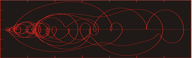
Dust flux, Vostok ice core

Dust flux, Vostok ice core
Two dimensional phase space reconstruction of dust flux from the Vostok core over the period 186-4 ka using the time derivative method. Dust flux on the x-axis, rate of change is on the y-axis. From Gipp (2001).
Showing posts with label sidescan sonar. Show all posts

Monday, December 15, 2014

One day on the beach

Winter is coming, and although it is not cold here as it is back home, my thoughts turn back to warmer days in Ghana.

The only food locally available was from a small restaurant run by a young woman named Sala. She has only a single charcoal stove, and can’t cook food quickly enough.

I wolfed down a hard-boiled egg, some boiled cabbage, onion, and pumpkin for breakfast. There was more of the same for lunch. We were on a parallel line approaching Shama when heavy rain came. We finished the line and ran into Shama towing the gear. The dorsal fin came off during the morning, but the instrument only flipped over once, and that was at high speed during our run in. Apparently at high speed, the weight at the front acts as a brake, and may flip the fish onto its back. Once it starts skipping across the water surface it will continue to do so. 

The data were still good despite the damage to the fish. Kabi has located some wood cut to shape that will be delivered in the morning.

We returned to port and unloaded the boat. As I was paying the boys, an old man came up to me and said he had not eaten and needed some chop money. I demurred, paid the boys and the boat owner. Once again the old man came asking for chop money. I am hungry he said. I too am hungry, I told him. Kabi explained to him that we too were under people, and that our money was not really our own but had to spent only on appropriate things. Oh, he begged, he was hungry. Then I remembered I still had lunch. I climbed into the back of the van, opened my bowl of food, and offered him a hard-boiled egg. He asked what else I had. I showed him the contents. Boiled onion, pumpkin, okra, a garden egg, and some cabbage. This food is too rough for me! he said. He returned the egg. He wanted a cedi. This is the food I am eating! I said. I will not give you a cedi so you can eat better than me. I took back the egg, but now didn’t really want to eat it. A quick, enterprising child held out his hand and I gave it to him. He ran off delighted, pursued by his peers.

The old man who refused my food came by the next morning, saying he would go and come and he would bring me money, so I could eat better too.

I did, actually. Sala had given me the same collection of boiled vegetables (including a whole onion) and eggs. But this time, the boys cooked light soup on the boat. They had brought a charcoal furnace (a hibachi, really), chopped up a fish, and cooked the whole thing on the rolling sea in less than an hour. The soup was explosively hot, but made a nice addition to my egg and boiled vegetables I had, turning it into a stew.

Monday, February 17, 2014

The village hammer

In response to the higher than usual amount of spam being sent to the World Complex, here's a little story. (BTW, thank you for your story about trying to get a loan from a god-fearing man, Mrs. Monica Roland. But the last time I was in Singapore, the unit of currency was not the pound).

We were about to run a small survey from a fishing vessel out of a small village in the western region. The geophysical gear had to be towed from the side, so I prepared to nail a beam to the boat, so we could tow the gear from a fixed point about 2 m off the side of the vessel. Unfortunately, my hammer had gone missing sometime during the trip--but one of our local employees told me he had one in his house just around the corner, so off he goes to get the hammer.

So we wait. And wait. And wait. A few hours pass, and then he returns with the hammer. I asked him what took so long. "Someone else was using it." Two minutes of hammering and we were done. Out to sea.


Not sure how clear this is to you, but this is a bit of raw seafloor acoustic imagery, with no navigational corrections (we wobble a bit and our speed changes due to wave action). The width of the image is about 90 m, and the length is a little over 500 m. The prominent light coloured bodies with the ripple marks are sand bodies with dunes; the darker material is soft sediment (silt), and the light blotches are bedrock outcrop.

Update: The image upload isn't that good. Bloody google.

Thursday, November 8, 2012

The creeping death of a fishery: Ghana (1980-2012)

On the short cool afternoons on our complex outside of Accra, we go up on the balcony, beverage in hand, and contemplate the sea.


Unfortunately the view isn't as good as it used to be, as there has been an explosion of building along the coast, especially hotels. In particular, hotels between us and the beach. So the picture above (taken last year) is not exactly current. But you can occasionally get a glimpse of the fishing boats returning in the afternoon between the block wall that now obscure our view.

Here's how it works. Around sunset, the fishing boats sail off and in the late morning--or possibly the afternoon, they return. The fishing is still pretty good near Accra if you go far enough offshore. The late upwelling has prolonged the good catches this year.

But fishing is meager in the eastern and central portions of Ghana. There used to be far more boats plying their trade than do now.

The artisanal fishery is of critical importance. Nearly 25% of Ghana's population lives in the coastal zone. Until the past decade, approximately 10% of the population depended on the fishery for their livelihood (Quaatey, 1996). It seems that that number has declined in recent years. I recall seeing estimates exceeding 30% for the amount of protein in the Ghanaian diet that came from the sea.


Climatic fluctuations over the past fifty years are reflected in the catches of artisanal fishermen (Minta, 2003), but it is not as clear whether the more or less monotonic decline in fish catches over the past decades can entirely be laid at the feet of climate change. Different species respond in different ways to climatic fluctuations--the most important being temperature, rainfall, and strength and duration of upwelling. But against climate change we need to consider the backdrop of changing technology in both the artisanal and mechanized fishing fleets.

In 1996, when I began work in coastal Ghana, I saw significant fishing fleets at many villages along the coast. In particular, the village of Nakwa, at the mouth of the Nakwa River, behind a lagoon fronted by an impressive sand barrier, had a large fishing fleet full of vessels at least sixty feet in length which landed on the barrier. The fishing boats were brightly painted and festooned with colourful banners. There were ferries constantly running across the lagoon between the village and the landing ground for the fishing fleet.

Two years ago I ran a sidescan sonar survey out of Nakwa between the river mouth and the offshore oil platform (GNPC-Saltpond). The fishing fleet was gone, but for a couple of dilapidated wrecks drawn up on shore. The locals told me there was no more fishing--anyone from the village who wanted to fish had to travel 150 km west to Axim, where the fishing was still good.


Nakwa lagoon in 2010.


Flaring gas near Saltpond.

In 1997, in the course of offshore work near Axim, we encountered the artisanal fishing fleet several km offshore at night. The canoes all used lights to lure the fish in where they could be netted. At the time, this was the most technologically sophisticated method of artisanal fishing. Since then, new technologies have been deployed, including underwater lights and the use of chemicals.

The use of technology by the artisanal fishing industry varies from locality to locality. In the far west of Ghana, there has been an attempt to manage the fishery by limiting certain methods (CRC), but such efforts are nearly always local.

This year (so it has been reported), the fishing has ceased off Axim, and the fishermen have been forced further west to Cote d'Ivoire.

Overshadowing the increased efforts of the artisanal fishery is the steady increase in industrial fishing effort.

In 2010 I observed pair-trawling (which is illegal in most places). Sidescan surveys show that the seafloor is crossed by abundant trawl marks, even in nearshore areas that are supposed to be off-limits to such techniques. Trawling disturbs large areas of the seafloor, reducing marine productivity for years.

As the trawling has entered into the waters which were reserved for the artisanal fishermen, it is little surprise that the inshore fishery has suffered.


References


[CRC] Coastal Resources Center / Friends of the Nation (2011). Assessment of Critical Coastal Habitats of the Western Region, Ghana. Integrated Coastal and Fisheries Governance Initiative for the Western Region of Ghana. Coastal Resources Center, University of Rhode Island,132 pages.

Minta, S. O., 2003. An assessment of the vulnerability of Ghana's coastal artisanal fishery to climate change. M. Sc. thesis, University of Tromso, Norway.

Quaatey, S. N. K., 1996. Report on the synthesis of recent evaluations undertaken on the major fish stock in Ghanaian waters. Marine Fisheries Research Division, Fisheries Directorate of the Ministry of Food and Agriculture, Tema, Ghana.

Sunday, February 27, 2011

Image of Musson and Passat off Newfoundland

As related here, the ships Passat and Musson were research vessels used by the Soviet Union to find suitable locations for hiding nuclear submarines on the Atlantic margin of North America.


Musson about to enter St. John's harbour in late June, 1986. The main thing
I remember is that they refused to allow the harbour pilot aboard.


Stern view of the Passat in St. John's harbour in early June 1986.

Friday, December 10, 2010

Steampunk sidescan sonar

Over the past couple of years I have been using a home sidescan sonar system to map portions of the continental shelf of Ghana.

Sidescan sonar uses sound to produce images that are analogous to aerial photographs of the seafloor. The images need to be interpreted and if you have the right technology you can stitch the images into a large mosaic which makes producing a map much easier.

Conventional systems run in the $40 thousand to $120 thousand range, but it is possible to make systems yourself for much less.

The system requires an electronics package which consists of a signal generator/receiver (typically a piezoelectric transducer) attached to a towfish, which is towed behind the vessel as it plows through the waves.

I have been using a Humminbird 1197c fishfinder, the transducer of which I have attached to a homemade towfish in order to add stability. The Humminbird is designed to run mounted on the transom, which is fine for small inland lakes and still waters, but is not suitable for marine operations.


The towfish is a 3" ABS pipe with wooden fins, held on by copper strapping. The transducer is the small black object on the bottom at the end of the coiled black cable. The fish is towed by a rope which is attached at a towpoint on the top near the front (we don't tow it by the electronics cable, although that is done on commercial systems). The rebar wired onto the front is to provide weight at the front and forces the fish down to a depth where the upward force of the rope balances the weight.


The copper strapping gives it a nice Victorian look. The screws were all hand-tapped, just like in the 19th century.


Old-time marine sonar, 1875. Image from Physics Today (don't recall the issue).

The system is being a little like a laser pointer that flashes in a series of straight lines across the seafloor, making one measurement in each instant, and later reconstructing all of the images into a coherent image. Now if your laser pointer is attached to a ship which is pitching and rolling all over, then instead of tracing out parallel lines on the seafloor, the laser pointer is going to illuminate the seafloor more or less randomly and the resulting image won't make sense.

The towed fish will tend to be more stable. At depth the wave amplitude is smaller and the data are less noisy.

Here is what the seafloor looks like illuminated by sonar.


For this image, the "colour" is related to acoustic reflectivity. Harder substances appear lighter in this image, so the dark background material is relatively soft silt. The sand bodies have dunes (the ripples). The image is about 90 m from left to right. Shoreline is to the right.


This image shows bedrock exposed at the seafloor. On the left side, the bedrock has been covered by fine sediments. The blocky structure within the bedrock reflects foliation in the bedrock (metasediments and metavolcanics). The bedrock surface is very rough with high (up to 2 m) peaks of bedrock, with acoustic shadows visible behind them.

Joining the images is very difficult with this system, but there is one advantage. The system is cheap and robust enough to use in the surf zone. I know of no commercial system with this feature.