Dust flux, Vostok ice core

Dust flux, Vostok ice core
Two dimensional phase space reconstruction of dust flux from the Vostok core over the period 186-4 ka using the time derivative method. Dust flux on the x-axis, rate of change is on the y-axis. From Gipp (2001).

Thursday, December 23, 2010

Reconstructed phase space portraits and charting

It's been awhile since we last checked in on Detour Gold Corp. (disclosure: long).

Over the past seven months, we have seen some nice price action, with a major rise in the early summer.

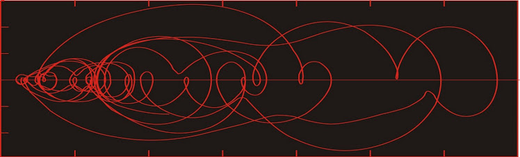
The two-d reconstructed phase portrait using the time-delay method with a lag of three days (as last time).


In our last installment on this stock the price was rising more or less monotonically. Now we see that what happened was a distinctive shift from one range (at lower left) to a higher price area, where the price has been bouncing around for awhile.

Looking at the two LSAs above, one represents a price range in the $21-25 range, and the second is $27-33. Should it fall out of this range, we would presume it could fall back into the other.

We can see a connection between the price chart and the reconstructed phase space portrait. It is clear that what we call confinement to a Lyapunov-stable area (and use as an indicator of at least temporary stability) . . .


 . . . may be perceived by the chartists as "trading within a range".


(Those diagonal lines aren't intended to be there--they magically appeared during the conversion of the above chart from excel to corel to jpg). 

If we look at the higher of the two Lyapunov-stable areas (LSA30), we see that different parts of it are occupied at different times.

Detail of LSA30 by month.

In particular, the regions of phase space centered at about $30 and at about $31.50 are visited at least three times, and several of those visits are characterized by small loops in the phase space portrait, suggesting quasi-stability. On the price chart above, those regions correspond with what chartists would call support and resistance. 

The phase space portraits of complex systems are often characterized by areas of high probability density, which are sometimes (if they have the correct characteristics) called attractors, but may more commonly be referred to as Lyapunov-stable areas (LSA). An LSA is an area in phase space where the state of the system tends to remain assuming there are no dramatic changes in the dynamics of the system. We would normally interpret such an area as evidence for a metastable state in that region of phase space.

If the state space of the system normally occupies an area below the range of values represented within the LSA, then the upper and outer limit of values will appear (on a one-dimensional chart) to be resistance--and chartists frequently describe such phenomena as the price "bouncing" off resistance.

If the state space of the system is occupying the region above the LSA, the chartists will term the lower boundary of the LSA to be "support".

If support is broken, it means the system has left the LSA, and is moving towards another one, presumably at a lower price. The chartist will say that support has failed, and will look back along the chart for the next region of support, which will have been the lowest value of the next lower LSA. If the price has broken down through an all-time low, then there is no telling how low the price will go.

If resistance is broken, the price may move towards the next higher LSA if one is present. If so, the highest value within the LSA will be seen by the chartist as "the next area of resistance". If the price has broken to a new all time high, then we are probably all in the dark.

Sunday, December 19, 2010

A New Invention.

Everyone here at the World Complex is thrilled about our latest invention--peanut butter and banana oatmeal!

Friday, December 10, 2010

Steampunk sidescan sonar

Over the past couple of years I have been using a home sidescan sonar system to map portions of the continental shelf of Ghana.

Sidescan sonar uses sound to produce images that are analogous to aerial photographs of the seafloor. The images need to be interpreted and if you have the right technology you can stitch the images into a large mosaic which makes producing a map much easier.

Conventional systems run in the $40 thousand to $120 thousand range, but it is possible to make systems yourself for much less.

The system requires an electronics package which consists of a signal generator/receiver (typically a piezoelectric transducer) attached to a towfish, which is towed behind the vessel as it plows through the waves.

I have been using a Humminbird 1197c fishfinder, the transducer of which I have attached to a homemade towfish in order to add stability. The Humminbird is designed to run mounted on the transom, which is fine for small inland lakes and still waters, but is not suitable for marine operations.


The towfish is a 3" ABS pipe with wooden fins, held on by copper strapping. The transducer is the small black object on the bottom at the end of the coiled black cable. The fish is towed by a rope which is attached at a towpoint on the top near the front (we don't tow it by the electronics cable, although that is done on commercial systems). The rebar wired onto the front is to provide weight at the front and forces the fish down to a depth where the upward force of the rope balances the weight.


The copper strapping gives it a nice Victorian look. The screws were all hand-tapped, just like in the 19th century.


Old-time marine sonar, 1875. Image from Physics Today (don't recall the issue).

The system is being a little like a laser pointer that flashes in a series of straight lines across the seafloor, making one measurement in each instant, and later reconstructing all of the images into a coherent image. Now if your laser pointer is attached to a ship which is pitching and rolling all over, then instead of tracing out parallel lines on the seafloor, the laser pointer is going to illuminate the seafloor more or less randomly and the resulting image won't make sense.

The towed fish will tend to be more stable. At depth the wave amplitude is smaller and the data are less noisy.

Here is what the seafloor looks like illuminated by sonar.


For this image, the "colour" is related to acoustic reflectivity. Harder substances appear lighter in this image, so the dark background material is relatively soft silt. The sand bodies have dunes (the ripples). The image is about 90 m from left to right. Shoreline is to the right.


This image shows bedrock exposed at the seafloor. On the left side, the bedrock has been covered by fine sediments. The blocky structure within the bedrock reflects foliation in the bedrock (metasediments and metavolcanics). The bedrock surface is very rough with high (up to 2 m) peaks of bedrock, with acoustic shadows visible behind them.

Joining the images is very difficult with this system, but there is one advantage. The system is cheap and robust enough to use in the surf zone. I know of no commercial system with this feature.

Wednesday, December 1, 2010

African Economics 2: Private vs. public transit

The traffic in Accra (Ghana) is incredible. A major problem is that the road network is inefficient as all traffic moving from one neighbourhood to another must pass through a single road. I had at one time believed this to be deliberate, so that in the event of a coup, traffic can be controlled from a few chokepoints.

But locals assure me that the reason is much simpler--the original plan was to have more of a grid network of roads, but after the maps were drawn up, the local chiefs sold the land needed for the extra roads. Once sold, the lands were developed, and as Ghana has no rules for expropriation, the roads could not be built.


The result is heavy traffic.

The cure is a transit system. But what kind?

Because of my experiences growing up in Toronto, it seemed unimaginable to me that a transit system could be run by any entity outside of government.

Then I saw the trotros running in Ghana.

Anyone with a minivan is free to start a service. Simply drive anywhere where there is a line of people,  suggest a destination, and see how many try to board.


People waiting at the local trotro stop at Dansoman.

At any major intersection there are one or more large areas assigned to transfering trotros. Additionally, there are known stops along major arterials and even on narrow back streets.

No one planned the location of these transfer points. They arose from the self-interested actions of the various market participants. The one near Mallam Junction is, admittedly, a little hard on traffic.


Trotro loading on Indepedence Ave.

The most interesting thing about the trotro system is its complete lack of central planning. It has arisen "organically" simply by the actions of self-interested participants. Nevertheless, it is a superior system to the parallel state transit system which tries to do the same thing.


State transit--like most buses, nearly empty.

When I saw all the state transit buses running empty I asked whether it cost more to ride the bus than the trotro. But Ghanaians have told me that the price of the bus is competitive. So the bus is empty presumably because it is not as convenient as the trotro. My contacts tell me that the system is fairly heavily subsidized, yet still doesn't compete against the humble trotro.

The main problem with the state transit system is that it is unable to respond to sudden changes in demand. The exact routes and the number of buses on each route is determined by bureaucrats who have no stake in the actual quality of the system--worse, the system reinforces bad decisions because the bureaucracy does not want to be seen to have made an error. So if empty buses shuttle back and forth along one route all day, while elsewhere thousands stand waiting for a bus that never comes, there is no incentive to change the system.


Waiting for a bus at the main bus station, Opera Square, Accra (also used as a car park).

In the privately run system, any trotro driver who sees nobody waiting to go on his normal route can change at will. Indeed, there is an incentive to do so, as it increases immediate cash flow. 

I was involved in a debate with a couple of our local contractors about transit a few weeks ago. Our naval architect was of the opinion that the private system was superior to any public system that could be developed, whereas our Ghanaian geologist was certain that a government-run system was the modern way to go. He seemed a little ashamed of the trotros.

I found his faith in government particularly disturbing, considering he was from a tribe that was displaced from its homeland by a singular government project.


Trotros at Kaneshie.

A couple of weeks ago, as we left SCC junction on the road towards Kokrobitie, I saw a very large line of people waiting for the trotro. For just a moment I had the urge to tell the driver to pull over, shout out "Bortianor!" and open the back of the truck. The driver assured me we would fill the truck, but on reflection I decided it probably wouldn't be wise. A western company has to worry about liabilities, unlike the local trotro drivers (at least they don't have to worry about them as much).