Dust flux, Vostok ice core

Dust flux, Vostok ice core
Two dimensional phase space reconstruction of dust flux from the Vostok core over the period 186-4 ka using the time derivative method. Dust flux on the x-axis, rate of change is on the y-axis. From Gipp (2001).
Showing posts with label Arctic. Show all posts

Friday, March 20, 2020

New charts - northern hemisphere Arctic sea ice maxima

A recent publication has highlighted the importance of the maximum extent of seasonal ice cover in the Arctic Ocean to the stability of the over all sea-ice system. So I have acquired data from NOAA of the daily sea ice extent since 1979, which I have used to find the maximum annual extent and the date (expressed as a Julian Day - so March 1, 2019 would be day 60, but March 1, 2020 would be day 61). These data sets will be studied in the usual manner, if appropriate. (I used the five-day trailing average, by the way).


The maximum sea-ice coverage has declined since 1979

The graph suggests that the maximum extent of ice coverage has declined more or less constantly over the observation period. There are a few ups and downs. In fact, something popped out at me. In the graph above, what do 1998, 2001, 2008, 2012, and 2020 have in common? They all represent years where sea ice extent increased - presumably due to cooling. They were also years with somewhat trying economic circumstances, at least for some people. Coincidence? Probably--but maybe it means there was an agricultural trigger to some of the economic crises of the past few decades.


There has been an idea that as global warming proceeds, the timing of certain important events will change, becoming either earlier or later. Investigating the above graph for a trend in the timing of the ice extent maximum each year tells me . . . nothing. If there is a trend, it is very weak.

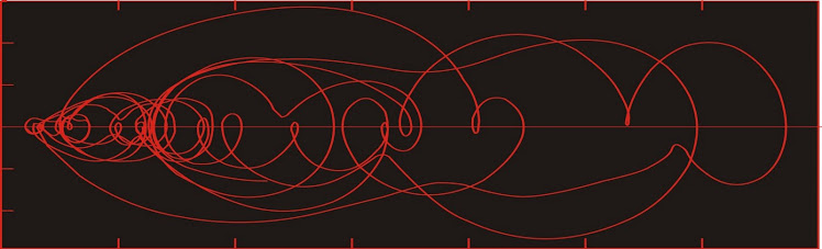
Below we have the 2-d reconstructed state space portrait of the annual maxima sea ice extent, using the time-delay method with a 2-year lag. 


The state space reconstruction shows three regions of stability. The S1 and S2 correspond roughly to the major area of stability in the sea-ice minima phase space, which may actually be two separate such regions, one larger than the other. S3 corresponds with the most recent low-area sea-ice minima.

As with the sea-ice minima plots, there is not enough data to determine the long-term future of this system. It is possible we are in a declining phase of a century-scale cyclical system. Alternatively, we could be on a decline to zero. We may even be in a biased cycle, where the natural cycle is being influenced by global warming. The problem is that the data are not sufficient to tell us which is the correct interpretation.

Friday, September 27, 2019

We have passed this year's Arctic sea ice minimum

and what do we see?

This site informs us that we have tied with 2007 and 2016 for the second lowest sea ice extent in the satellite era--4.15 million sq km.

This gives us the wherewithal to update our phase space reconstruction of the sea ice extent.


We are near the middle of the same area of metastability we have been in since 2007. There is no way to tell how long we shall continue in this region of metastability; nor do we know if we will return to the higher region of stability occupied prior to 2004, or drop to another lower region of stability or fall to zero (as many disaster models predict).

All we can do is keep watch.

Saturday, September 22, 2018

Arctic sea ice minimum 2018

We are near the Arctic sea-ice minimum for 2018, which is projected to be 4.6 million square km


This gives us another point on our 2-d phase space projection. There is actually very little change from last year. I still only see two main areas of Lyapunov stability, although its possible there was a separate solution prior to the mid-1980s, when the system was confined to a much smaller region of phase space.

If the hypothesis of human activity on climate is correct, then we might interpret the first significant change as having happened around 1980, when the system expanded into a greater area of phase space. In colloquial terms, we would say that the variability of the system increased markedly.


Increased variability is potentially one of the markers of human influence on climate. If so, then the first irreversible change we see in our data occurred around 1980. The next one happened shortly after 2000 when the system migrated from one area of Lyapunov stability to another.

Monday, September 25, 2017

After the recent Arctic sea ice minimum . . .

. . . we have a new reconstructed state space diagram.


This year's minimum is 4.64 million sq km, which is a nice improvement from last year, and keeps the chart well within the lower area of Lyapunov stability proposed here about four years ago. With each passing year, my confidence that we have really entered an area of stability grows.

It is still unclear when the system will break out of its current area of stability, and what it's most likely behaviour will be (the two main contenders being a return toward the earlier area of stability at upper right, or a continuation towards the ice-free conditions forecast by so many. .

Saturday, August 26, 2017

More Arctic landforms

More shots from a commercial flight (Toronto-Shanghai), which passed over the western Canadian Arctic, and eastern Siberia.


 Snow-filled drainage pattern on Melville Island, in the western Canadian Arctic.


Well-developed trellis drainage pattern on Melville Island.

The trellis drainage pattern results because the rocks are more easily eroded in some directions than in others. This can be due to bedding in the rock, or faults or other structural weaknesses. The pattern here is quite angular, which suggests faulting to me. Rocks undergoing compression tend to develop two (almost) perpendicular series of faults. 

There's also a rather deep-looking canyon in the above two pictures. Normally to get a canyon, you are looking at fluvial erosion over land that is experiencing uplift.Something more has happened here, as it is difficult to follow the canyon through the folded rocks of the Melvillian Disturbance just above the centre of the second photograph above. These rocks were folded and faulted prior to deposition of Late Permian sediments (~250 Ma).


Melville Island again, but I'm not quite sure what I'm looking at. It looks like some of the folded and faulted rock units of the Melvillian Disturbance.


This is over eastern Siberia. I'm really not sure what this is. My first guess would be a pingo, but given our altitude of 10,000 m and the focal length of this shot, it has to be well over 1 km long, which seems awfully big. Maybe it is an inselberg.


Some rugged terrain in eastern Siberia.


Looks like gossan. Who'd have thought there would be minerals in Siberia?

Don't be too quick to go out staking here. I don't see a lot of infrastructure.


Braided rivers in Siberia.


Thursday, August 24, 2017

Ice under cloud

Yesterday's flight took me north from Toronto, over Hudson Bay and into the western part of the Northwest passage, then over Melville Island and on into the Arctic Ocean.

These are digital photos from a commercial flight, with some post processing to balance colours.


Looking down through clouds at ice floes in the western part of the NW Passage.


I'm not sure whether the larger agglomerations of ice are parts of the ice pack that haven't broken up entirely, or are part of the multi-year ice that has broken free from islands or ice shelves..


Sea ice seen through a couple of holes in the clouds.


In the Arctic Ocean, we seem to have flown over an area where the ice hasn't broken up at all. We can clearly see frozen leads in the ice.

Sunday, February 19, 2017

Scenes from a plane

I took a few shots from the plane during my return to China last week.


Sea ice in Hudson Bay. Impressive leads, with some refreezing.


Snow in northern China


Part of the Great Wall, viewed from the air.

Sunday, October 23, 2016

Landslide in Alaska - aerial views

In the past two years there have been some spectacular avalanches in Alaska.

The first happened in Icy Bay, and caused a tsunami estimated to have been nearly 200 m high.

The second happened earlier this year in Glacier Bay, a little farther south, and seems to have missed the water, but left a large deposit on top of the ice.

Here are a couple of pictures of the second landslide, taken about two months ago as I flew over Alaska.


Wednesday, October 19, 2016

Arctic sea ice still hanging around

Another autumn, another sea ice minimum to add to the chart I have been posting yearly for awhile now. This year's minimum was about 4.1 million square km, among the lowest measurements on record.


Nevertheless, there still is not enough information for us to distinguish among several competing hypotheses.


1) The variation in sea ice is part of a dynamic natural cycle, which is currently in a lower area of Lyapunov stability, but which will at some point return to the higher area of stability (as it was prior to about 2003). There are alternatives to this hypothesis, such as the sea-ice system may naturally oscillate between two or more states, but this oscillation is being modified by anthropogenic effects.

If we are observing a natural cycle, and its duration is related to the time observed within the higher area of Lyapunov stability, then at some point the system will return to the area of stability occupied prior to 2003. The typical duration of natural climatic cycles is from a few years to decades. Given the length of time that the system occupied the higher Lyapunov-stable area, I would assume we are looking at a fairly long cycle length--meaning even in the best-case scenario (no anthropogenic effects) we would expect to remain in this state of lower sea-ice extent for at least another decade. A breakout, if it occurs will be towards the right first, before curving up toward the higher area of Lyapunov stability.

If anthropogenic effects are modifying the trajectory of the system, then we may still get an upward breakout, but it may be a short-lived one where the state does not reach the higher area of Lyapunov stability before falling back, either to the current Lyapunov-stable area, or possibly to a new, lower one. Even if, during the breakout, the system reaches the higher area of Lyapunov stability, it may remain there only a short time before returning to the present one or perhaps a lower one.

2) The variation in sea ice extent is in secular decline, likely driven by greenhouse gas emissions, but the dynamics of the natural system have temporarily arrested the decline in the current area of Lyapunov stability. In this case, we may expect the system to remain within this area of Lyapunov stability, before breaking out to the left and arcing downward.

Distinguishing between these differing hypotheses needs more time, but unfortunately we run the risk of an irreversible change occurring as we wait. Better would be to extend the record backwards by several decades, which can probably only be done by collecting near-surface sediment cores, and looking at their microfossils.

Wednesday, July 6, 2016

Coastal Alaska

Good weather when flying down the coast of Alaska, on the way to Vancouver from Beijing. My first photographic survey of the coastal glaciers there in about 20 years.


Glacier, trailing to the upper right.


Mount McKinley (Denali to Alaskans) in the distance.


Glacier feeding into a lake, with another at top.


Glaciers cascading into a fjord.


If this is the one I think it is, it has receded quite a lot in the last twenty years. Most of the water in the foreground was under glacial ice the last time I photographed it.


All of these were photographed digitally, and the colours were rebalanced afterwards. The original shots are too blue. The brownish shading on the left is a reflection from the edge of the window.