Dust flux, Vostok ice core

Dust flux, Vostok ice core
Two dimensional phase space reconstruction of dust flux from the Vostok core over the period 186-4 ka using the time derivative method. Dust flux on the x-axis, rate of change is on the y-axis. From Gipp (2001).
Showing posts with label Geology. Show all posts

Saturday, January 18, 2020

The History of the East Asia Monsoon

So I went to Washington DC last week for the AGU Chapman Conference on the East Asian monsoon. I found it to be a very rewarding conference, and even learned a bit about navigating around Washington on transit, as I was on a limited budget.

The conference was in AGU headquarters, which is near to Dupont Circle.


Not all that far from the Mall, although I didn't visit this time.


Speaking of scientists . . .

I was speaking during the opening session, which was about climate dynamics (and its role on the changes in monsoonal strengths through geologic history). A major dynamic role has been the rise of the Himalayan mountains and the Tibetan Plateau during the period of interest, and there is still a lot of debate about the importance of these tectonic events on the development of the monsoon. Some of the modeling studies suggest that the mountains only change the specific location of the rainfall, and that monsoon behaviour may occur even if there were no continents at all.

My work was based on analysis of global to regional proxy data sets, and has been summarized in all these places. Unfortunately, due to limited time, after working through the phase space reconstructions, I had to rush through the statistical computation part, and wasn't certain whether any of the message made it to the audience ungarbled. Fortunately, I was able to learn that at least some members of the audience understood the message.

The afternoon sessions were all about paleoceanographic records of the monsoon. Over the past decade, the International Ocean Discovery Program (IODP, formerly ODP and DSDP) has put down a number of boreholes in the Indus and Bengal Fans, and other boreholes in the Huang He fan and the Sea of Japan also provide useful records of at least some parts of the monsoon. The records I studied were generally global in scope--these other records allow for regional variations to be studied.

The next day's sessions dealt with continental environments (a common issue was the change in photosynthetic pathways of plants in response to environmental change during the Miocene) and records of continental erosion. Erosion is important because either rising mountains or increased rainfall will lead to increased erosion.

The last session was on modeling the effects of tectonic uplift as well as changes in the timing of the uplift, because there is still some disagreement about when the Tibetan Plateau was formed. I mean disagreement between it being less than 10 million years ago to more than 40 million years ago, which is a significant difference of opinion for something so recent.

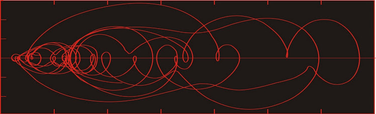
The last portion of the conference was to break up into groups for focussed discussions on topics of interest leading to the testing of several hypotheses proposed at the start of the conference. I started off in the wrong room, so I was  with the tectonic modeling people rather than the climate modeling people, but was still able to ask about whether anyone had successfully had chaos appear in their model output. Results were inconclusive.

For the second group meeting I joined the combined discussion between the climate modelers and the paleoceanographic records group. Over the course of the discussion I eventually managed to come up with a proposal. See if the modelers observe chaos, and see if they can tell which style of chaos they have. Such chaos will be manifested as spatial variability in some climate effects, such as the location of the maximum rainfall. The models may have the type of spatial variability modeled correctly, but the specific timing of variations will be incorrect. That spatial variability will be recorded in the widely spaced paleoceanographic records which already exist. They type of chaos observed in the models will tell us what to look for in the cores; from the cores we can obtain the correct timing of the modeled chaotic spatial variations of the monsoon system.


Exiting the Metro Station at Dupont Circle

I wasn't sure how the last part of the conference would go--early on, many of the old hands were of the opinion that nothing ever comes from these things. But I thought it was pretty rewarding, particularly as it was during these sessions that I came to realize that people felt that whatever I was doing was worthwhile.

Alone in my corner of the world, I had never been sure.


Night flight back to Toronto

Wednesday, June 12, 2019

Image of recrystallization of niobium minerals in a carbonatite

From a location that will remain secret for now.

Every so often I get out of my hospital bed and look at some rocks. This image comes from a rock slab I took down to the SEM lab in the Geology Department at the University of Toronto last month some time.

Most people have some idea of how a scanning electron microscope works. Fewer will know about an attachment that many of them have--an energy-dispersive X-ray analysis detector. This device allows for estimation of the elemental composition of a point on a mineral (or a section of whole rock) in a non-destructive fashion.

Blasting a sample with electrons (how the SEM works) ionizes the target area--when it recaptures an electron it releases a quantum of energy in the X-ray spectrum that is characteristic of the element that has been ionized. This allows for the specific elements to be identified and their relative amount quantified.

A second method of analysis involves back-scattered electrons, which create a grey-scale image that results is grey scale, with lighter coloured grains containing heavier elements.


The backscattered electron image above tells me that the white grains have the heaviest elements in them. The X-ray spectrum (not shown) tells me that the heavy element present is niobium. The mineralogy work previously done suggested that the principal niobium-bearing mineral present is pyrochlore--but the x-ray spectrum suggests that many of these grains are actually ferro-columbite (as columbite, but Fe>>Nb), pseudomorphed from pyrochlore.

The gangue minerals are represented by two different regions of grey. The light grey can be shown to be phosphates (mainly apatite) and the darker grey is carbonate (mainly dolomite).

The image above captures something interesting. The columbite grains have begun to lose their distinction from the gangue minerals. Niobium and other heavy elements are being shifted around (the bright white "tendrils" surrounded by black [=silica]) by some late-stage fluid reaction. The x-ray spectrum shows that in addition to Nb, there are rare earth elements present (mainly cerium). This suggests alteration of the columbite to possibly fersmite--although I haven't isolated grains well enough to establish the crystal structure yet.

I wanted to share this because I think this is a spectacular image--from a scientific perspective. From a metallurgical perspective, we would prefer not to see all of those little unrecoverable tendrils of Nb and Ce locked in silica.

Thursday, October 11, 2018

The new New Age

Anthropocene is a movie which appeared in the Toronto Film Festival this year. It has since gone on to appear in a few cinemas hereabouts.

It is a visually striking film. But if you are already familiar with its message, it is a little slow.

The movie trailer is unfair to the gentleman from Hong Kong who owns the ivory shop. All of the ivory depicted in his segment in his store is fossil ivory, something made clear in the film, but not the trailer. I went to one such shop when I visited Hong Kong--if you want a carved tusk, you can have one for about the price of a house.

I first encountered the term "Anthropocene" as a proposed name for a new geological epoch--one in which the forces modifying the earth's surface are dominated by human activities--in 1987 or 1988, in an issue of Geology. I only remember the time because it was when I was in Newfoundland, and looking back casually through recent publications only shows more recent references.

The original article was very short, and as I recall, attracted a firestorm of responses in the form of letters to the editor. Most of these suggested alternative names to this epoch, ranging from "Neocene" and "Cenocene" (often accompanied by dry, pedantic discussions about why one name was superior to another), but there was one clever wag who proposed we call this new epoch the "Shouldhavecene". Yes, we should have.

Anthropocene seems to have won out, or at least it has the upper hand.

Thirty years ago the world was a different place. At the time the first article appeared, it seemed like a joke, this idea that humans could dominate the surface features of the planet. Part of this is a kind of blindness. Grow up in cities surrounded by farms and this landscape seems like the most natural in the world. Add to this Canada's managed forests, some tourism commercials, and it was easy to think that nearly the entire country was untouched wilderness.

Onwards in the theme of human impacts on the world. Yesterday we had the second (annual?) Progressive Mine Forum, held in the MaRS Discovery District, which is a sort of breeding tank for tech industries. It covered numerous themes related to modernizing the industry, from mechanization, reducing fossil fuel usage, "green" mining, battery metals, and so forth.

Quote of the day: "You know who likes big trucks? Ten-year-old boys and mining engineers." I think that was Nathan Stubina of McEwen Mining.

Interesting idea of the day: Just as Uber is the largest taxi company in the world (which owns no taxis) and Airbnb is the largest hotel chain in the world (which owns no hotels), might there arise a large mining company that owns no mines? The speaker, George Hemingway of The Stratalis Group mentioned that Apple is proposing to use only recycled material in their products. What if they do the recycling? What if they became so good at it that they begin to supply recycled material to everyone else. Apple (or any other large tech company) has a huge advantage over traditional mining companies--they have no trouble attracting financing to projects with no projected return.

Saturday, March 4, 2017

Dinosaurs

This will be short--there are extreme VPN problems in China now, and it is uncertain when I can post again. I am finding that almost all sites are blocked, even with the VPN.


Tarbosaurus sp., on display in Hustai Mall, Ulaanbaatar.

Mongolia's principal dinosaur museum is in a suburban mall. I guess the idea is to go where the kids are . . .


Sauropod on display in Chicago O'Hare airport.

Thursday, January 26, 2017

"It's like being on the Moon!"

. . . said just about everyone about the terrain around Hamningberg.

Hamningberg is an abandoned fishing village in the northeast tip of eastern Finnmark--the northern part of Norway. The town was largely depopulated in the 1960s, although people still used some of the homes there as summer cottages. There was even a small coffee shop (or was, in 1993). What made the town special is that it is one of the few villages where buildings predate the war.

When the Germans retreated from Finnmark during the last winter of the war, they were ordered to burn everything. However (so I was told), the commander of the German forces stationed in Hamningberg took pity on the people, and so he disobeyed the order. This was probably made easier knowing that no other German units would be passing through to realize this. So while every other village in Finnmark was razed, Hamningberg remained.


 Things to do in town include visiting the abandoned German gun-emplacements, and, if you have a flashlight, the pillbox and the network of tunnels between ammunition storage areas, the observation area, and the rails for the gun.


WW2 vintage barbed wire


The picture quality isn't all that great--the slides look okay, but the scanner isn't doing a very good job of scanning them.

What I was most interested in seeing in the area was the landscape. Everyone I knew in Finnmark told me that going there was like going to the moon. Even this site describes it as a "moonscape".


Just for reference, here is a real moonscape.


The local geology around Hamningberg consists of alternating sequences of sandstone and shale, which have been folded so that the bedding is nearly vertical. The shale tends to get eroded out, but the more resistant sandstone beds remain as broken walls across the landscape. Craters are absent. So, the place doesn't look like the moon at all.


But there is something otherworldly about the place. I think the reason for this common description--like the surface of the moon--reflects the fact that the landscape looks radically different from any other landscape that most people have ever seen.

For one thing, there isn't a lot of vegetation. But (at least here in Canada), there are a lot of shield areas with practically no vegetation. The other reason has to do with the geometry of the landforms of the area.


In the early days of computer-generated landscapes, there were experiments in which people would be shown some of the simulations and asked to rate them as being realistic or not. Most of these landscapes were generated using simple rules, with a seed shape (usually a triangular pyramid) and a characteristic fractal dimension. It turns out people were remarkably good at picking out the landscapes which had fractal dimensions within the typical range of landscapes on earth. Anything outside of this range was "otherworldly".

For a computer-generated landscape to resemble Hamningberg, it may have to be seeded with rectangles rather than pyramids. I don't think the fractal dimension is anything unusual, however. But the description of the area is being otherworldly may reflect the preferences that people have for landscapes that conform to their ideas of what constitutes a "natural" landscape.


Monday, April 11, 2016

Wuhan does geoscience

One of the lesser-known sights in Wuhan is the University of Geosciences. The campus in Wuhan seems mainly to be the undergraduate campus, whereas the graduate school for geology is in Beijing.

The first notable building seen from the main road is the museum, which is rather striking.


I knew that the museum was along the road here somewhere, but I didn't expect it to stand out like this. Travel blogs had stated that there was an entire forest of petrified wood nearby. In fact there were only a few pieces.


Other rocks on display outside the museum included stromatolites and a big chunk of "peony stone", which is some sort of porphyry.

I had heard all sorts of outrageous numbers about the number of students at the University of Geosciences. Numbers exceeding 100,000 from a certain site more well known for pumping stocks. According to this site, there are just over 25,000 students, but there are numerous programs.

This number of students is awfully impressive compared to those in geological programs in countries with geology in their history--Canada, for instance.

The campus itself is something of a disappointment.


Obligatory sculpture of a guy with a geologist's hammer.


Aging, nondescript buildings


A gate

The place was dead, but then we had just entered the spring holiday.

Even the museum has seen better days. My first day in Wuhan, it was closed. It was only going to open on the weekend, and only for a limited number of people.

It was cold inside. Apparently, they don't heat the building in the winter on the days when it is closed.


I think this is the part inside the big ball.


An early seismometer. Probably every museum in China has one of these.


Like all museums, fossils are front and centre. Unfortunately, the lighting was terrible in a lot of the galleries, so


One of the main reasons to visit geoscience museums in China. Dinosaur eggs

Good dinosaur fossils are common at all three geoscience museums I visited (the one in Nanning was closed, seemingly permanently, and I couldn't locate the one in Guilin). Henan province, where I am staying, is home to many of the best dinosaur-fossil locales.


The other reason to visit geoscience museums in China. Feathered dinosaur fossils.

Wednesday, February 24, 2016

Karst features of Guilin, part 2

In our last installment, I showed you some images of karst terrain near Guilin.

That is what is above the surface. Today let's look at what lies beneath.

Karst topography arises from dissolution of carbonate rock. But most of this dissolution does not occur at the surface. It occurs at depth. Today's feature concerns spelunking.

There are numerous caves in and around Guilin. Now, one of the charming things that the Chinese like to do in their natural parks is to "improve on nature" a little bit. In the caves, this was mainly in the form of strange lighting, but I suspect in a couple of areas, there was a little bit of construction as well.

Okay, I get it. You are trying to attract tourists to the caves, and they really aren't that interested in actual geology. Instead you talk about how this group of stalagmites over here resembles the Buddha giving a talk before the assembled monks, and this formation over here looks like ice cream, and this column over here resembles a dragon, and this one looks like Orlando Bloom smoking a joint (ok, I made up the last one).


The dissolution of rock makes the hole. If it is entirely underground, we call it a cave. Some of these features from holes or tunnels through masses of rock, like the examples above--most people don't think of these as caves.

On the flip side, once water levels fall, and the cave is dry, you start to get precipitation of minerals in existing spaces at all scales.


Stalactites, stalagmites, columns.


Flowstone.

The caves above include Seven Star Cave in Guilin, and the Silver Cave in Yangshuo.